Civil 3D Automation for Survey, Mapping & AEC Production
AO Logic
Less repetition. More production.
AO Logic builds practical Civil 3D, CAD, GIS and geospatial workflow automation for survey, mapping and AEC production teams—eliminating repetitive work, connecting disconnected processes, and automating the parts of production that don't require technical judgment.
Repetition is costing more than you think.
AEC teams deal with manual CAD cleanup, property research, inconsistent field-to-finish behavior, duplicate data entry, disconnected CAD/GIS workflows, and repetitive deliverable setup.Across surveying and mapping, skilled people are spending valuable production hours on work they have already done dozens or hundreds of times before.Property research. FEMA checks. CAD cleanup. Field-to-finish corrections. Moving data between CAD and GIS. Rebuilding the same deliverables project after project.The firms that solve that problem gain that time back. The ones that don’t keep paying for it on every project.
Real Production Examples
Built for the Production Between Collection and Delivery
Examples of tools and workflows already being used in real survey, mapping, reality-capture, and AEC production.
DATA AUTOMATION
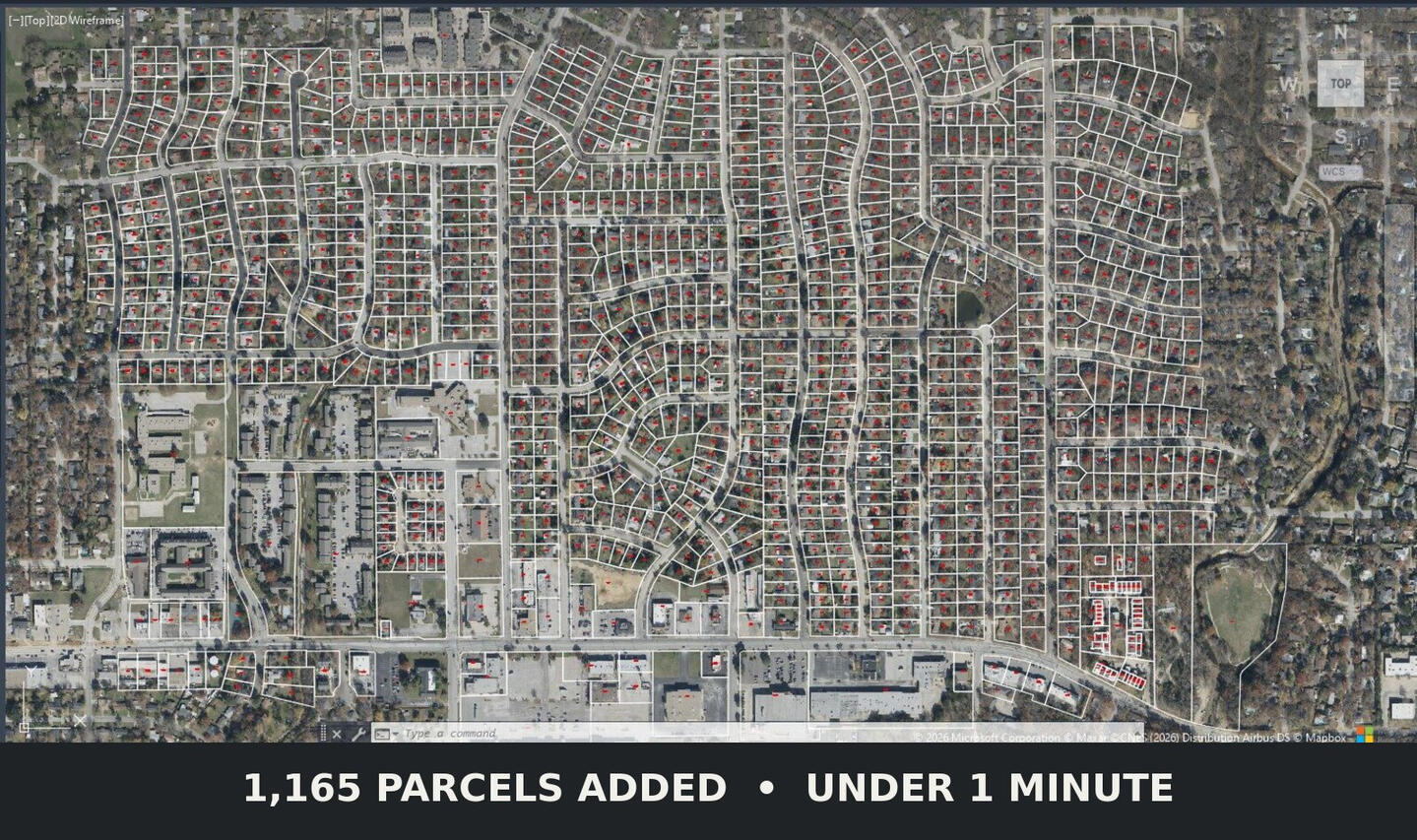
Parcel + Property Ownership Automation for Civil 3D
Retrieves available county parcel data and builds usable parcel geometry directly inside the production drawing, replacing repetitive manual research and CAD setup.
CONNECTED WORKFLOW
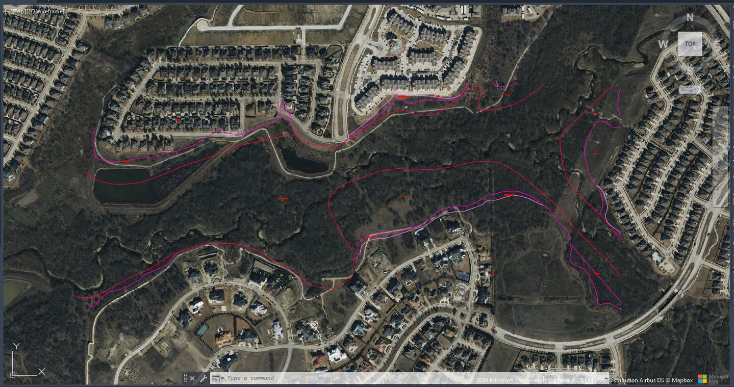
FEMA / FIRM Data Automation for Civil 3D
Pulls applicable FEMA flood data into the drawing coordinate system, separates and labels zone linework, and downloads the corresponding FIRM panel in the same workflow.
Civil 3D & CAD Production Automation
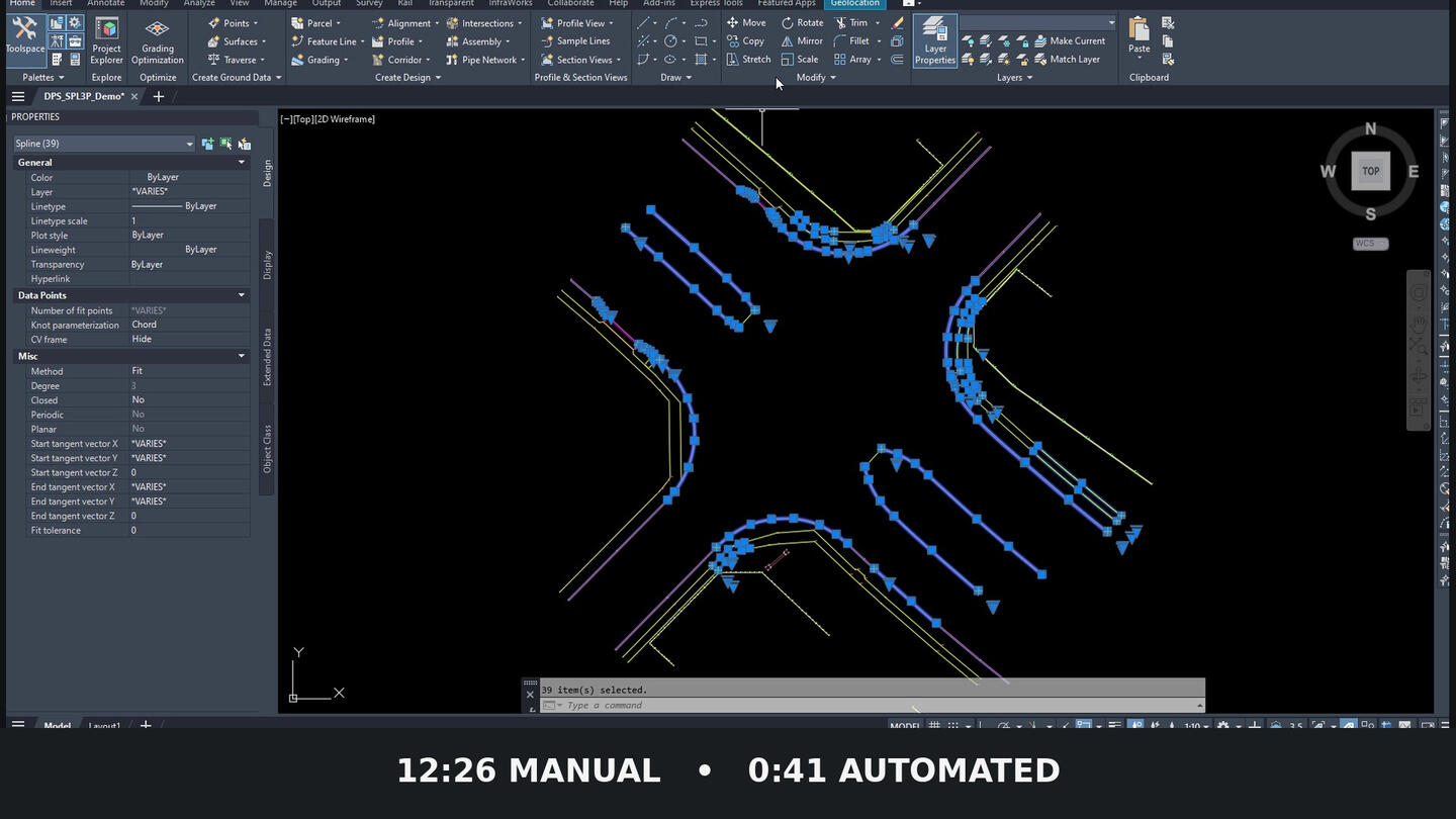
3D Polyline → Spline Automation
Uses field point-code modifiers to identify curve segments and automatically replace portions of 3D polylines with properly layered, elevation-aware splines with matched end tangency.
SPATIAL INFORMATION SYSTEM
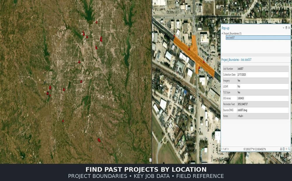
CAD to GIS Spatial Archive
Turns completed jobs into a location-based spatial archive, making past projects easier to find by where the work happened instead of by job number or folder structure.
Where
AO Logic
Applies
From small routines that save minutes to multi-step workflows that remove hours of manual production work.
Workflow Analysis
Review an existing production workflow, identify where time is being lost, and design a cleaner process before deciding what should actually be automated.
Property & Parcel Data Automation
Automate repetitive property data workflows including parcel linework, ownership labels, FEMA records and client ready reports.
Standards, Templates & Structure
Improve templates, layer standards, annotation behavior, file organization, and other production infrastructure that affects consistency across projects.
Production Automation
Build practical automation around repetitive production work, from focused tools and routines to multi-step workflows that connect software and data sources.
CAD, GIS & Spatial Data Systems
Design practical ways to organize, move, and reuse spatial information across CAD, GIS, project records, and other production systems.
Reality-Capture Production Support
Help streamline linework extraction, cleanup, and downstream production workflows tied to LiDAR and reality-capture data.
Workflow Automation Review
AO Logic has identified recurring production tasks across surveying and mapping that consume far more time than they should. We build practical tools and automation around those problems to reduce repetitive work and give production teams more time back.Reach out and we’ll walk through where the bottlenecks are, what’s causing the repetition, and where automation or process changes would make a difference.
One defined workflow review
Bottleneck and repetition analysis
Automation opportunities
Written findings and recommended next steps
Buildout work quoted separately
Audit credited toward buildout
ABOUT AO LOGIC
Built from firsthand production experience.
AO Logic was built from firsthand experience with the production problems that survey, mapping, and geospatial teams deal with every day.Some of those problems are small: a repetitive task that costs 10 or 15 minutes on every project. Others consume hours of drawing cleanup, research, or data handling. When the same work repeats across dozens or hundreds of projects, the cost adds up quickly.Just as important, repetitive work takes time away from the decisions that actually require experience and judgment. Instead of spending hours checking websites, copying numbers, redrawing information, or cleaning the same geometry by hand, that time can be spent on the parts of the work that actually need a skilled person.That perspective comes from experience across the production chain, from field collection through CAD, GIS, LiDAR, point-cloud processing, and final deliverables.We’ve worked with traditional survey equipment, terrestrial scanning, mobile and aerial LiDAR, Civil 3D, GIS, point-cloud registration and extraction software, and the real-world process of turning field data into something a client can actually use.That experience also exposed a common disconnect. A tool may technically be capable of doing something, but the people designing it do not always understand how that information is used in the finished deliverable.Knowing how to detect a breakline is one thing. Knowing which breakline matters, what it represents in the field, and how it affects the finished surface is something different.That’s the gap AO Logic is built to bridge.We’re not approaching these workflows as software developers looking for somewhere to apply automation. We’re approaching them from the production side, with firsthand experience collecting the data, processing it, cleaning it up, and ultimately delivering it.The goal is simple: identify the repetitive parts of production that don’t require technical judgment, automate them where it makes sense, and give that time and attention back to the people doing the work.
Talk Through a Workflow
Have a repetitive task, production bottleneck, or workflow that keeps eating up time? Tell us what’s happening. A short description is enough to start the conversation.
Inside the Work
A closer look at the tools, workflows, and results behind the examples above.
Parcel + Ownership Automation
1,165 parcels added to CAD in under 1 minute
THE PROBLEM
Property research and CAD setup can require technicians to repeatedly locate parcel data, retrieve records, draw or import boundaries, format information, and label properties one at a time.
THE WORKFLOW
The custom tool retrieves available county parcel information, transforms the data into the drawing coordinate system, and builds usable parcel geometry directly inside CAD from the identified project area.
THE RESULT
In this example, 1,165 parcel boundaries were retrieved, labeled, added to the production drawing and a parcel report was generated in under one minute, replacing a substantial amount of repetitive manual setup.
FEMA / FIRM Data Automation
FEMA LINEWORK + FIRM PANEL • UNDER 1 MINUTE
THE PROBLEM
Manual FEMA research requires locating the site on FEMA's website, finding and downloading the correct FIRM panel, interpreting the site location, downloading FEMA spatial data, importing and transforming it into the drawing coordinate system, sorting zone linework onto the correct layers, and labeling the flood zones.
THE WORKFLOW
The user defines the project area in CAD. The workflow retrieves the applicable FEMA flood data, transforms it into the drawing coordinate system, builds zone-specific linework on the correct layers, labels the visible flood zones, and downloads the corresponding FIRM panel for reference.
THE RESULT
The recorded example completes the FEMA data pull, coordinate transformation, linework creation, zone labeling, and FIRM-panel download in under one minute. A process that can take roughly 10–20 minutes manually becomes a repeatable CAD workflow with minimal technician input.
3D Polyline → Spline Automation
THE PROBLEM
Converting coded 3D polyline curves manually means finding each curve, breaking and deleting the appropriate segment, rebuilding it point by point as a spline, adjusting its tangent direction, and moving it back to the correct layer.
THE WORKFLOW
The routine reads start, stop, curve, and curve end point code modifiers to determine where spline geometry belongs. It preserves fit point elevations and the original layer, then automatically adjusts spline tangency to match the adjoining 3D polylines.
THE RESULT
On the dataset shown here, the same cleanup took 12 minutes 26 seconds manually and 41 seconds with the automated workflow.On small drawings, the workflow can save tens of minutes; on larger production drawings, it can eliminate hours of repetitive geometry cleanup.
CAD to GIS Spatial Archive
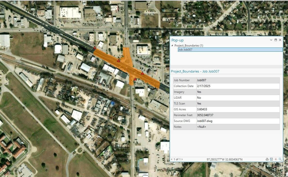
A location based project archive that organizes completed work spatially, making previous jobs easier to find, review, and reuse.
THE PROBLEM
Past projects are often buried in number based filing systems, which only work best when someone already remembers what to search for. This can cause time consuming searches to find a job and what data was collected for a particular project.
THE WORKFLOW
Completed jobs are stored in a GIS-based spatial archive with project boundaries, dates, job size, available imagery/LiDAR/scan data, and related field reference information. Project age can also be visualized with a green to red freshness scale.
THE RESULT
Users can navigate to an area, identify previous projects, and immediately review key project information, such as control, property markers and acquired data types, making historical job lookup, data reuse, and field mobilization much faster.
© 2026 AO Logic. All rights reserved.
Software automation for the built environment.